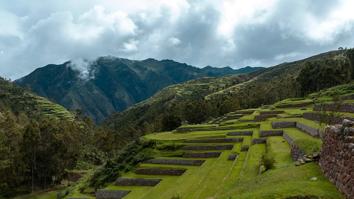

Choquequirao does not have art galleries. It has no members-only bar, no doorman, no velvet rope. What it does have is an entire Inca city spilling down a ridge above the Apurímac canyon — roughly 1,800 hectares of it — with only about a third cleared of cloud forest.
So take the title seriously but not literally. The "galleries" here are stone halls, terrace walls and carved niches. The "private clubs" are the viewpoints you can only reach on foot, after two days of climbing, where the only other members are the handful of people who bothered to show up.
That's the trade: you pay in sweat and you get a major archaeological site almost nobody is standing in. Here's how to do it well, cheaply, and without buying a tour you don't need.
Unlimited High-Speed International Travel eSIM
Connect in seconds across 180+ destinations. Instant QR code activation with zero roaming surcharges.

At a Glance: Choquequirao
- Best time to visit: May to September — dry, clear mornings. Avoid January to March, when the lower trail turns to mud and landslides close sections.
- Typical daily budget: S/120–250 (~$32–65 USD) self-guided and camping; S/450–700 (~$120–185 USD) with a guide and mules.
- Local transport style: Bus to Curahuasi, shared taxi to Cachora, rough taxi up to the Capuliyoc trailhead. After that: feet, and one sensible mule.
- Vibe: Dusty, silent, no phone signal, cold at night, brutally steep in the middle. Nobody is trying to sell you anything.
The Llama Terraces: Choquequirao's Strangest Gallery
On the lower southwest flank, a long flight of terraces holds something you won't see anywhere else in Peru: more than twenty llamas built into the terrace walls in white stone. Their bodies and necks are picked out in pale quartz against the dark fieldstone, all facing out over the canyon.
Archaeologists still argue about what they were for — a ceremonial herd, a marker on the route toward Machu Picchu, an offering to the mountain. They were cleaned and consolidated in the 2000s, and they remain the most photographed thing at the site. Photographed does not mean crowded: you can easily get ten minutes down here alone.
- Sector: Andenes de las Llamas, lower southwest sector, about 20–25 minutes below the main plaza.
- Cost: Included in the site ticket (roughly S/60 / ~$16 USD).
- Best time: 7–9 a.m. By mid-afternoon the west face is in shadow and the white stone goes flat.
- How to get there: Follow the stone stairs down from the Plaza Principal. Steep and uneven — allow 45 minutes round trip.
Insider tip: Guided groups usually reach the llamas around 10 a.m. and are gone by 11. If you camp at the ruin campsite, walk down at first light instead — the only sound is the Apurímac River about 1,400 metres below you.
The Hanan Plaza and Its Two Usnus
The upper plaza is the closest thing Choquequirao has to a main hall: a broad grassed rectangle ringed by long kallankas — halls with multiple doorways and trapezoid niches — that once held ceremonies, weaving and storage. Two stepped platforms, usnus, sit at the edges, and the whole space faces a wall of mountains.
Stand in the middle and look at the stonework. This is not Machu Picchu's polished imperial masonry; it's rougher, more functional, more human. You can see where different work crews built different walls.
- Sector: Hanan (upper) sector, at the top of the main staircase.
- Cost: Covered by the same ticket.
- Best time: Right after opening, around 6–7 a.m.
- How to get there: 15 minutes' walk up from the campsite and guard post.
Insider tip: Sit on the eastern edge of the plaza just after sunrise. The light clears the ridge and hits the usnu first — it's the best photograph at the site and almost nobody waits for it.
The Qolqas: Choquequirao's Storage Gallery
Higher up, a cluster of small, tight rooms with ventilation niches served as qolqas: storehouses for maize, chuño and coca. The wind rips through here, which was the point — moving air kept the grain dry.
They're easy to skip and worth ten minutes. Look for the double-jamb doorways and the way the buildings step with the slope instead of fighting it. It's the most practical architecture at Choquequirao, and it tells you more about daily life than any temple.
- Sector: Upper terraces, above and behind the main plaza.
- Cost: Included.
- Best time: Midday, when the plaza is hot and this slope catches the breeze.
- How to get there: 10 minutes' walk up from the plaza on the main path.
Insider tip: This is where the wind is strongest — a good place to dry a soaked rain jacket in twenty minutes. Bring a layer; it's noticeably colder than the plaza.
The Water Gallery: Channels, Stairs and the Casa de la Cascada
Choquequirao's engineers ran canals down the entire hillside, and a long staircase follows one of them past a series of small drops. In the dry season you can still hear water moving in sections of the channel; in the wet season the whole slope becomes the waterfall it was designed around.
The building known as the Casa de la Cascada sits near the base of this run, tucked against rock. It's one of the more atmospheric corners of the site and, because it's another ten minutes down, frequently empty.
- Sector: Lower eastern sector, following the canal line.
- Cost: Included.
- Best time: Late morning, when light reaches into the stairwell.
- How to get there: From the llama terraces, continue along the lower path for about 15 minutes.
Insider tip: These steps stay wet even in the dry season. Trekking poles earn their weight here — and again on the climb back up.
The Unrestored Rooms: The Collection Nobody Can Enter
Roughly two-thirds of Choquequirao is still under cloud forest. You can't walk into it — it's a protected zone with unmarked drops — but you can stand at the cleared edge and see walls with trees growing straight out of them and doorways opening onto nothing.
This is the strangest gallery of all, because you're looking at what the site looked like before anyone came with a machete. Ask the guardaparques where the current clearing line sits; it moves each season as excavation continues.
- Sector: Edges of the excavated zone, especially the northern terraces.
- Cost: Included.
- Best time: Before 10 a.m. for the best light.
- How to get there: Marked paths only. Do not push into unexcavated bush.
Insider tip: The most common mistake here is wandering off-trail for a better photo. There are 30-metre drops under that vegetation, and rescue is a long mule ride away.
The Private Club: Dawn at Marampata and the Capuliyoc Balcony
Two places hand out the closest thing to a membership card. The first is the Capuliyoc viewpoint at the trailhead, where the canyon opens up and you finally understand what you've signed up for. The second is Marampata, a farming hamlet about two hours above the river and 40–60 minutes below the ruins, with family-run hospedajes and the best sunrise view on the trek.
There's a real decision here. Camp at the site's official campsite for a 6 a.m. walk into the ruins. Or sleep at Marampata for a bed, a hot meal and a dawn view over the canyon before the climb. Both are good; don't try to do both.
- Neighborhood: Marampata hamlet on the ridge; Capuliyoc is at the trailhead above Cachora.
- Cost: Hostel beds S/30–50 (~$8–13 USD); campsite S/10–15 (~$3–4 USD) per person.
- Best time: Sunrise. Cloud lifts out of the canyon between 6 and 7 a.m. in the dry season.
- How to get there: Two days on foot from Cachora, or one very long one if you're fit and start before dawn.
Insider tip: Book a Marampata bed through your Cachora hospedaje before you set off. There are only a handful of rooms, and arriving at 5 p.m. on a Friday is a genuine gamble.
Where to Eat and Drink Nearby
None of these take cards and none have a website, so carry small bills. Prices are what locals pay, plus a small trail premium.
- Cachora plaza comedores — the family kitchens around the Plaza de Armas serve a menu del día of soup, rice and grilled trout (trucha frita) for S/12–18 (~$3–5 USD). This is your last proper meal before the trail, so eat late and eat well.
- Marampata family kitchens — S/15–25 (~$4–7 USD) for soup, rice, egg and coca tea. Order the night before with your hospedaje; nobody keeps a stocked kitchen at 2,900 metres.
- Playa Rosalinas river stalls — huts at the bottom of the canyon sell water, beer and garlic soup at a markup (S/8–12 / ~$2–3 USD). It's the only cold drink for six hours in either direction, so budget for it.
Practical Logistics, Costs and What to Skip
Getting to the trailhead is the part most people get wrong. From Cusco, take a bus toward Curahuasi or Abancay (3.5–4.5 hours, S/30–50 / ~$8–13 USD), then a shared taxi to Cachora (40 minutes, S/50–70 / ~$13–19 USD). From Cachora, a taxi up to Capuliyoc costs S/70–90 (~$19–24 USD) and takes 30 minutes on a rough road.
There are no permits or daily quotas here, unlike the Inca Trail. You register with your passport at the checkpoint near the site, pay the entrance fee, and walk.
| Item | Cost (PEN) | Approx. USD |
|---|---|---|
| Site entrance ticket | S/60 | ~$16 |
| Cusco to Curahuasi bus | S/30–50 | ~$8–13 |
| Cachora to Capuliyoc taxi | S/70–90 | ~$19–24 |
| Mule plus arriero, per day | S/70–100 | ~$19–27 |
| Campsite, per night | S/10–15 | ~$3–4 |
| Marampata bed, per night | S/30–50 | ~$8–13 |
| Menu del día | S/12–18 | ~$3–5 |
Money-saving moves: split one mule between two people (S/70–100 / ~$19–27 USD per day, arranged in Cachora), carry a filter bottle instead of buying water, and skip the agency trek if you're comfortable with a map and an offline trail file.
What to skip, honestly: any "two-day Choquequirao tour" that promises the ruins and a comfortable return. The climb out of the canyon is roughly 1,600 metres of vertical gain, mostly on stone steps, in heat. It's doable, but it will be the hardest day most travellers have had in years.
Be sceptical of cable-car talk, too. The Choquequirao teleférico has been "two years away" for over a decade. Until you see towers in the canyon, plan on walking. Expect sandflies at the river, thin signage at the ruins, and zero phone signal from Capuliyoc onward.
Frequently Asked Questions
Are there real galleries or private clubs at Choquequirao?
No, not in the art-gallery or nightclub sense — there are no bars, exhibitions or members-only venues anywhere near the ruins. The "galleries" are the Inca halls, qolqas and terrace walls, and the "private clubs" are the remote viewpoints and hamlets you can only reach on foot.
Do I need a guide for the Choquequirao trek?
No. Independent trekking is allowed and there's no permit quota like the Inca Trail; you register at the checkpoint and pay the entrance fee. A guide is still worth the money if you want the archaeology explained or you've never done a multi-day high-altitude trek.
How many days does Choquequirao take?
Most people do four days and three nights from Cachora, camping at Playa Rosalinas and Marampata. Very fit hikers push it to three days, but that leaves no margin for weather, illness or altitude problems.
Is Choquequirao worth it compared to Machu Picchu?
Yes, if you want solitude and don't mind earning it — you'll often share the ruins with fewer than twenty people. If your trip is short or you're not up for a hard multi-day hike, Machu Picchu is the better use of your time.